Groundwater Flooding – Early Alerts for Winterbourne, Dorset
Groundwater flooding in parts of Southern England provided a final, disruptive signature on what has been another challenging winter. We review a specific event, showing how it was tracked to provide communities with the best preparation possible.
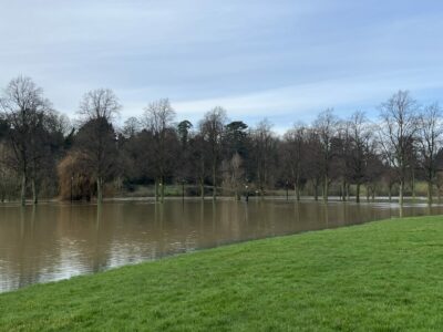
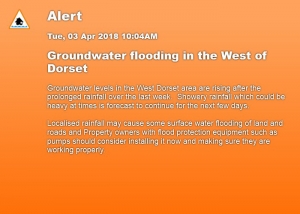
The Winterborne Valley in Dorset can be affected by high groundwater levels, due to the underlying chalk. This acts like a sponge, storing water, and giving rise to springs when groundwater levels are high. These levels can fluctuate considerably throughout the year depending on rainfall.
The period through early March to early April 2018 saw a steady cumulative rise in levels. This was due to a combination of snow melt and cyclonic weather systems.
While river flooding is more immediate and predictable, rising groundwater is more difficult to protect against. Flooding can occur from groundwater rising into property from underground sources – usually springs, rather than from river courses.
Groundwater Monitoring in Action
The Winterbourne is classed as a Main River, meaning it has full Environment Agency (EA) Flood Management planning along its course. It is fed by a myriad of springs which emerge whenever the groundwater reaches a critical level. These can suddenly flood onto the roadways and emerge beneath homes, as well as potentially damage sewage tanks. This means it doesn’t behave in the way a typical river flood would.
GeoSmart provides real-time monitoring of the Winterbourne and many other streams and catchments in groundwater flood-susceptible areas across the south of England. It provides the Flood Forecasting Centre (FFC) with advance notice alerts once threshold trigger levels are reached.
It is used to support FFC decision making at a national scale and promote early engagement with local Environment Agency (EA) teams and local authorities.
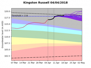
In the Spring 2018 event, the above Graphs for each borehole show the actual historical groundwater levels over the past 30 days. GeoSmart’s Flood Forecasting Tool uses the next 10 days’ weather forecast to determine the potential groundwater level during that period.
Looking further ahead, a probabilistic forecast is provided. This traces the combination of the rainfall forecast and historical climatology from the past 30 years. Threshold levels are set relative to the forecast groundwater elevations to indicate the likely onset of groundwater flooding.
Better Flood Resilience Planning
Predictive groundwater levels are mapped on an online interactive platform and fed into the FFC control room. Here, it is used to inform analysis on future groundwater levels and key areas to monitor.
This gives more time for first responders to prepare ahead of possible groundwater flooding incidents. It enables smarter resilience planning and helps provide critical answers on when and for how long flooding could occur.
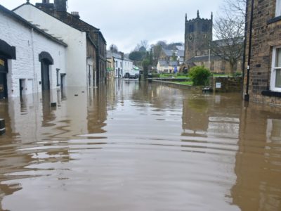
Our modelling called out the risk of groundwater emergence early for the Winterbourne valley communities, which then affected roads through Winterbourne Steepleton and Martinstown. It also threatened householders’ septic tanks. The bow wave from passing vehicles also caused problems for cottages adjacent to the roads affected.
For utility companies, this provides an essential early warning that key assets – like a pumping station or electricity sub-station that lies in the path of these emerging streams. This ensures they can deploy staff and resources in good time to protect the asset and avoid costly failure or disruption. Crucially, it helps avoid breaches of environmental regulations.
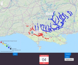
Alert levels are triggered by the percentage of locations that exceed the threshold with a colour coded system mapped for catchments.
The first early warning system for groundwater flooding
As our climate changes, so do threats from flooding to where we live, work and run essential services. Groundwater flooding has the longest duration (months) of all flood sources, but has been the least understood risk, – until now.
GeoSmart’s forecast service, GWFlood, is the UK’s first national early warning system on groundwater flooding for property, infrastructure and public service providers.
Live feeds from groundwater levels and weather forecasts are combined with daily updates of actual rainfall data and 50 years of borehole data. These then map risk predictions up to 90 days in advance. Results show the percentage likelihood that groundwater flooding will occur within a specific time period, as well as its duration.
A bespoke interactive map provides warnings on catchment risks. It also allows users to quickly look at forecast groundwater levels on a site-by-site basis.
This world class innovation provides an excellent example of the power of open data.
For more information about GeoSmart’s Flood Forecasting Tool, click here, email us at enquiries@geosmartinfo.co.uk or call us on 01743 298 100