Double Trouble: Two Shropshire Floods in Two Days
Shropshire bore the brunt of two severe flash floods that came in quick succession to the county affecting town and countryside alike. We review events and show that flooding is not all about rivers.
The plume of humid, moist air that was drawn up from France last week was more reminiscent of July or August days. It was inevitable that the price to pay would be rain and floods. The storm track curved across from East Anglia, into the West Midlands and onto the Welsh Borders, gathering in intensity as it picked up the heat from the ground.
The first floods struck in South Shropshire affecting Ludlow and Craven Arms and the process repeated with more intensity a day later in Shrewsbury.
20 homes were damaged by surface water flowing into properties, with the Local Authority urging people to get sandbags, isolate the electrics, move valuables, food and drink as high up as possible.
In Shrewsbury, within minutes, many roads resembled rivers, as the deluge had nowhere to go on the hard surfaces. Drains could not keep up with the run-off, adding to problems down slopes where the water gathered. Video footage shows these events in dramatic fashion.
In Coleham, water was around 2ft deep within an hour, closing roads and shops in its sudden ferocity.
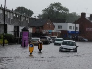
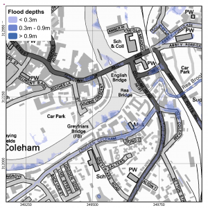
- Photo: Andy Richardson. Contains Ordnance Survey data © Crown copyright and database right 2018. Environment Agency copyright and database rights 2018.
Coleham (left picture above) and Wyle Cop in Shrewsbury are identified as at risk of flooding from surface water in mapping (right map above).
To highlight how localised these floods were, Telford at the time was basking in warm sunshine, while a rain gauge in Porthill, Shrewsbury recorded 38.8 mm in a one hour period.
While the county is well used to flooding from the larger rivers Severn and Teme, these events prove that it’s the smaller streams and culverts that can quickly swell, overtop and run into properties anywhere and at any time. If culverts are blocked or the flow impeded, floods will find any way they can driven by the local geography. The Severn, in comparison, is far better managed and more predictable.
In urban areas, it’s the sheer extent of hard surfaces that compounds problems – focusing the run-off into a surface drainage system that has failed to keep pace with climate change.
Our flood risk analysis shows how the smaller streams in Muxton are clearly unable to handle peak loads like these storms, while Shrewsbury’s town centre slope profile meant that a deluge was always going to direct water towards Coleham and Frankwell.
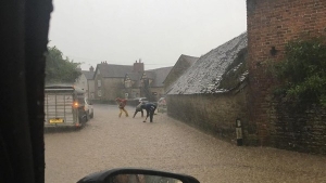
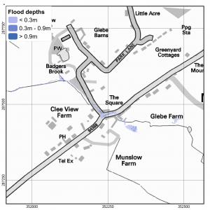
- Contains Ordnance Survey data © Crown copyright and database right 2018. Environment Agency copyright and database rights 2018. Photo: Russell Bufton.
Flooding on the B4364 in Muxton (above left) has been identified in the surface water flood risk mapping (above right).
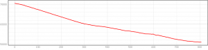
The above graph clearly demonstrates the steep profile along a road into Frankwell, Shrewsbury – emphasizing how storm water floods were able to migrate down into the valley and collect in and around property.
GeoSmart understands how river, surface and groundwater flooding can affect property and development sites. For more information about our desktop flood risk assessments call us on 01743 298 100 or email enquiries@geosmartinfo.co.uk


