What is a phase 1 desk study report and why is it needed?
A phase 1 desk study forms part of a contaminated land risk assessment. The study aims to provide a qualitative assessment of the risks to end-users and the surrounding environment from any contamination which might be present on or in close proximity to the site.
The phase 1 desk report uses various sources of information including historical Ordnance Survey maps, aerial photographs, local and national archives, geological records, groundwater vulnerability maps, and regulatory records.
What is the purpose of a phase 1 desk study?
The purpose of a phase 1 desk study is to determine:
- The likelihood that sources of contamination are present within the subsurface beneath the site or near by.
- The consequence or severity of any impacts should contamination be present.
- The risks posed by the site to the proposed future users, buildings and the wider environment.
What guidance is followed to conduct a phase 1 desk study?
Currently, the contaminated land reports follow the CLR11 document which was created in 2004 – the CLR11 is due to be withdrawn by the end of 2019 and replaced with updated guidance Land Contamination: Risk Management (LCRM). The process of assessment is administered through the planning process and individual reports may be assessed by the Contaminated Land Team or Building Control Officers within the Local Planning Authority. Each Local Authority will have their own guidance providing specific local requirements for a contaminated land report which must be followed if approval is to be granted.
When is a phase 1 desk study required?
There are many scenarios which require a phase 1 desk study, however here are the main three developers will come across:
- Planning conditions – a phase 1 desk study may be required in order to validate a planning application, or to satisfy planning conditions usually described as a “Phase 1 Preliminary Risk Assessment”.
- Building warranty – The National House Building Council (NHBC), or other warranty providers, may request a phase 1 report to support the building warranty.
- Due diligence – prior to purchasing land it is prudent to identify and evaluate any potential risks associated with the site and the potential obligations that the buyer will be required to undertake.
What is included in a phase 1 desk study?
A GeoSmart phase 1 desk study includes the following:
Report Summary – a clear outline of the findings and recommendations for the Site.
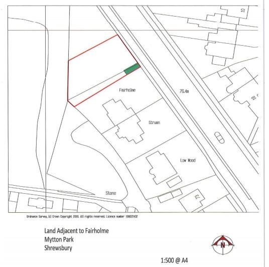
Introduction – This section includes background information about the location of the Site, the purpose of the report, report contents, report limitations and a Site location plan.
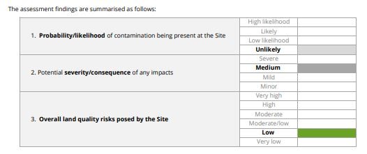
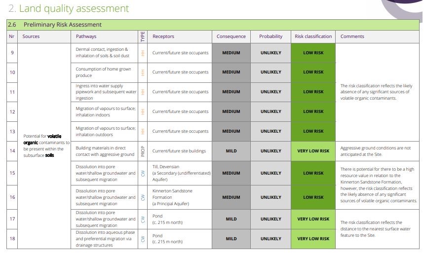
Land Quality Assessment – This section includes relevant information which helps to establish the site’s environmental context and site history. It will detail the Site’s current use, neighbouring industrial land use, Environment Agency recorded pollution incidents, details of landfill/waste sites within 500m, radon and many more environmental considerations. The section concludes with a Preliminary Risk Assessment which classifies all potential pollutant linkages identified and assesses the potential source – pathway – receptor relationships between each.
Lots of supporting information is provided with the report, including any photographs taken during a walkover (if required), data supplied by third parties and copies of any relevant planning history or Site investigations.
What is a walkover?
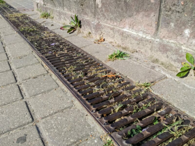
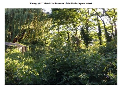
A Site walkover is where a qualified and experience Contaminated Land Consultant visits the Site to check and verify the current condition of the land. The consultant will make a photographic record of the Site condition and provide a description of activities and observations which will form part of the phase 1 report. Many Local Authorities specify that this walkover must be undertaken by an independent and qualified person, rather than the landowner.
How do I know if I need a site walkover?
In the first instance, review the conditions in your decision notice. If you are unsure, GeoSmart are happy to review the planning condition for free and you can email details to enquiries@geosmartinfo.co.uk. The planning condition does not always reference a walkover, therefore we would consider the current condition and use of the land and check the relevant local authority guidance on contaminated land reports. We find the majority of local authorities require a walkover. Typical sites that require a walkover can include land with current or former industrial uses, petrol stations, car parks and garages (commercial and residential).
Does GeoSmart contact my local authority?
Yes, we contact the Contaminated Land Officer at the relevant local authority to discuss the Site and to see if they have any additional information or concerns.
Are the demands of all local authorities the same?
Typically the demands are similar and in line with CLR11 planning guidance. However, we have found that some, including Epping Forest District Council, have more specific requirements and ask for their own data to be included. This means a request has to be made to Epping Forest, for example, and they can take up to 20 working days to respond.
There is no contamination on-site, why do I need a report?
Some Local Authorities require that a phase 1 desk study is submitted with each and every application to confirm that there is no risk of contamination being present. More commonly the report is requested to support the discharge of a planning condition. This condition will have been added at the request of the Contaminated Land or Building Control teams because records held by the local authority give them reason to believe there are historic uses which may have caused contamination. Also, the future use of the land is important; if for example the land has previously been used for commercial use and a residential use is proposed, then this is a more sensitive end-use and requires more consideration in respect of potential contamination.
How long does a phase 1 desk study take to complete?
A phase 1 desktop study typically takes up to 5 working days. If a walkover is required then delivery of the phase 1 report is usually guaranteed for 5 working days following the site walkover.
What happens once the phase 1 desk study is complete?
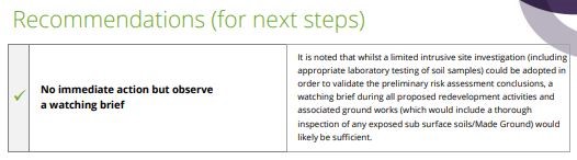
In many cases the phase 1 risk assessment is sufficient to satisfy the Local Authority, Building Control or warranty provider that the risks are sufficiently low and no further work is required. In some cases, depending on the outcome, recommendations are made which can include further data collection, phase 2 site investigation or remediation/mitigation. The reports make clear and pragmatic decisions on the level of risk posed and offer proportionate solutions.
For more information on phase 1 contaminated land reports or any of our environmental reports, call us on 01743 562262 or email enquiries@geosmartinfo.co.uk.