Prior Approval Application to Convert an Agricultural Barn to Residential Use
We were commissioned to undertake an EnviroSmart Plus report to support a Prior approval application to convert an agricultural barn to residential use. The Phase 1 Contaminated Land Assessment presented a clear and concise overview of the land quality issues presented by the former long term agricultural use of the Site.
The client was aware that it would be necessary to submit a contamination survey as part of the prior approval application given the buildings change to a more sensitive end-use. The Contaminated Land Officer at Horsham District Council was contacted to establish any particular concerns and pick up on any additional information they may hold. This ensures that when the report is submitted our recommendations are well informed and address any specific issues. The contaminated Land Officer stated that his main concerns related to possible made ground and given the former agricultural use of the Site, there was the possibility for fuels to have been stored and for leakages from machinery to have occurred.
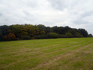
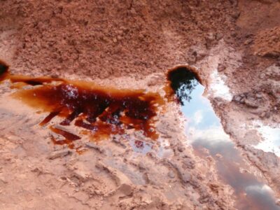
The Site walkover which is included in the EnviroSmart Plus report allowed a qualified consultant to visually inspect the Site for any evidence of made ground or staining and vegetation stress which could be related to spillages of oils, fuels or lubricants. A full photographic record was taken to provide a full representation of the site and verify existing site conditions with the council. The Site walkover showed no visible signs of contamination with the exception of a small area in the centre of the Site which appeared to have been used for burning waste materials. As the Site building was constructed post 2000 there was unlikely to have been any asbestos within the building fabric and no evidence of asbestos materials were observed during the Site walkover.
A range of data was collated to draw together an overall picture of the site and the surrounding environment, so that a conceptual model could be produced. This enabled the risks to local sensitive receptors of concern to be identified and qualified.
The proposal included the option for a comprehensive collection of Ordnance Survey National Grid, County Series and Historical Town Plan mapping at 1:10 000, 1:10 560, 1:2 500, 1:1 250, 1:1 056 and 1:528 scales. These sets of maps allowed the Site’s boundary to be accurately identified in relation to neighbouring land uses over time.
In order to identify the contamination risk at the site, we purchased an environmental data report as part of the Phase 1 investigation. A review of the environmental data showed the underlying geology consists of Weald Clay Formation beneath the Site. Given the geological classification of unproductive strata, and the lack of any resource value to any local groundwater, the risk classification for geology and groundwater was consider to be minor.
An overall risk assessment was produced qualifying the contamination risks posed and the sensitivity of the receptors of concern. The conclusion was that the site was low risk leading to a recommendation that no further action is required. However, as the Site is located within an area more likely to have high levels of radon, it was recommended that radon protection measures are included in structures during the redevelopment phase.
The EnviroSmart Plus Report delivers both clarity and exceptional value and are available for £995 plus VAT.