
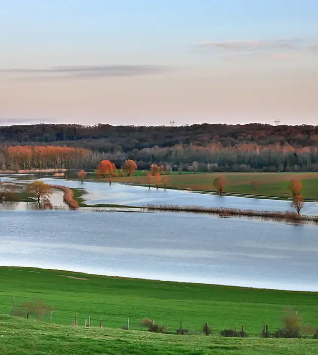
Flood Risk Reports
Fast, Compliant, Hassle-Free
GeoSmart Information delivers Flood Risk Reports to architects, planners, developers, and legal professionals, ensuring smooth planning applications, property transactions, and insurance processes.
Rated Excellent on Trustpilot
What are Flood Risk Reports?
Our Flood Risk Reports will typically consider a range of factors, including the location of the property, the elevation of the land, the risk of flooding from rivers, seas, or groundwater, and the potential impact of flooding on the property and its surroundings.
If your site is in a flood zone 2 or 3 (or over 1ha in a flood zone 1/in a critical drainage area/at high risk of surface water flooding) a flood risk report must be completed before the development starts to ensure that the site will be safe from flooding in the future. The report must take climate change into account when assessing the risk of flooding. If risks are found, the report will provide possible solutions to reduce the risk of flooding on the development. This will help you to plan and safely mitigate these risks.

4,000+
Environmental reports provided.

3 million+
UK property transactions used GeoSmart data.

£900 Billion+
Value of properties advised on flood risk
Trusted by


Choose the right report for you
Looking for the right Flood Risk Report package for you? At GeoSmart, we have three assessment options, all giving clear flood management options and fast delivery times to help you prepare to manage risks that may occur on developments. Find out more about our different report options below.
 Floodsmart
Ideal for sites in Flood Zone 1
From £1,050 + VAT
- Flood Risk Assessment (FRA) Report
- Flood zone 1
- Floodsmart Plus
Ideal for sites in Flood Zones 2 & 3
From £1,195 + VAT
- Flood Risk Assessment (FRA) Report
- Flood zones 2 & 3
- Floodsmart Pro
Ideal for sites in Flood Zones 2 & 3, with the addition of a site visit
From £1,895 + VAT
- Flood Risk Assessment (FRA) for each Site provided
- Flood zones 2 & 3
- Site Visit
Features
What our flood risk reports feature
01
Follows standard guidance from the Environment Agency and aims to meet the requirements of individual Local Authorities
02
Easy-to-read format using a visual ‘traffic light’ risk rating
03
Provides a review of available flooding data
04
Simple attenuation volume of water provided
05
Consultation is undertaken with the Environment Agency and Local Authority where appropriate
06
Suitable to accompany a SuDS report as requested by Local Authority
Benefits
Why you should choose our reports

Produced by specialist hydrologists with over 15 years’ experience.

Our consultants have built a great working relationship with Environment Agency and Local Authority Officers across the UK.

Flood risk reports are widely accepted in support of planning applications and insurance.

Quick turnaround options available
Low cost / fixed price
Frequently Asked Questions
Navigating environmental reports can be complex. We’ve answered the most common queries about our data, timescales, and planning suitability below.
Can’t find the answer? Our consultancy team is here to help.
A Flood Risk Assessment is required for any planning application where the site of the proposed development is located within Flood Zones 2 or 3 as defined by the Environment Agency. Such sites are considered to be at risk of flooding and the Environment Agency and local planning authorities have the power to challenge planning applications that have not taken into account all of the flood risks involved.
A Flood Risk Assessment is also mandatory for sites of 1 hectare or greater in Flood Zone 1, as well as for sites in a critical drainage area, sites at risk of surface water flooding, and where the long-term flood risk map shows the site is at increased risk of flooding from rivers or sea during its lifetime.
If your Site is in England, your site will be located in a Flood Zone as defined by the Environment Agency for planning purposes. To find out what Flood Zone your site is located in, input your postcode into the Environment Agency Flood Map for Planning available online.
If your Site is in Wales, your site will be located in a Flood Zone as defined by Natural Resources Wales for planning purposes. To find out what Flood Zone your site is located in, input your postcode into NRW’s Flood Map for Planning available online.
If your Site is in Scotland, your site will be located in a Flood Zone as defined by the Scottish Environment Protection Agency for planning purposes. To find out what Flood Zone your site is located in, input your postcode into SEPA’s Long Term Flood Risk Map available online.
- House builders and developers
- Property professionals such as architects, planning consultants and land agents
- Lawyers and solicitors
- Lenders, banks or mortgage providers
- Businesses
- Private individuals
- Insurance companies
- Asset managers
- Validating planning applications
- Meeting planning conditions
- For land and property purchase
- For the sale or divestment of a site
- Due diligence
- Lending, mortgages, pension funds
- Business risk assessment
- Asset manager portfolio
A FloodSmart Report for Sites located in Flood Zone 1 can be delivered within 5-10 working days.
Delivery of reports requiring EA, NRW or SEPA consultation and data (FloodSmart Plus and FloodSmart Pro) is dependent on their response times to supply such data, which can typically take up to 20 working days. Typically your flood risk report will be dispatched within 10 working days from receipt of the required data.
A premium delivery is available if your report is urgent – do get in touch and let us know.
Your report will be sent in electronic format as a .pdf file straight to your inbox, with hard copies available at an additional cost.
Local planning authorities are likely to request a Flood Risk Assessment for any site which is situated on the modelled flood plain, and within the vicinity of a fluvial or tidal watercourse.
Flood Risk Assessments are also requested in areas of low fluvial or tidal flood risk if a proposed development is over one hectare in size and/or lies within a critical drainage area.
Different levels of flood risk assessment reports are required for different purposes. We’ve therefore developed a range of products which are suited to meet the various needs of our clients. If you’re not sure which level of report you need please contact us at enquiries@geosmartinfo.co.uk.


Ready to get your quote?
Our environmental reports are second to none in terms of quality, compliance and current data. We also provide £5m of PI cover for all reports and services.
Simple online form, no obligation
Additional services
- Sequential Test
- Exceptions Test
- Basement Impact Assessment
- Portfolio Screening
- Flood Evacuation Plan
- Groundwater FRA
- Flood Consequence Assessment (Wales)
- BREAAM Flood Risk Assessment
- Compensatory Floodplain Storage Analysis
- Coastal Erosion Vulnerability Assessment
- S19 reports
We also provide reports for:

Contaminated Land
Reports assess whether a site has potential land quality issues, state who and what is at risk, and outline the solutions available.

Sustainable Drainage
Reports help to assess which drainage options are available for a Site in order to comply with national regulations.
Flood Risk Assessment Resources
CPD Webinar
This on-demand session will deep dive into key sources of flooding (including groundwater), the associated risks to development, approaches to catchment management, what Flood Risk Assessments involve, and how to successfully discharge flood-related planning conditions.
By watching our CPD-accredited webinar, you will add to your CPD points.
Knowledge Hub
One of the biggest constraints will be flood risk zoning for development. Your role is to identify what the limitations are and the potential design responses where development would be allowed. You need to assess the site in the context of its flood zones, engagement with the regulators and review of the Local Authority’s Strategic Flood Risk Assessment.
We’ve compiled guidance, FAQs and Case Studies on Flood Risk Assessments.
Key blog posts
We’ve compiled our key blog posts on Flood Risk Assessments:
What our customers have to say

“The service provided was efficient and friendly. From the first phone call to GeoSmart they provided a clear, professional approach to my request within the timescales advised. Great service and I would have no problem recommending”
“We are very pleased with the service provided by GeoSmart. Their reports have been used to assist with numerous planning applications and have always been delivered to budget and on-time, much to our clients’ appreciation. We look forward to working with GeoSmart on future projects.”
“Efficient and friendly service, GeoSmart provided a clear and concise report within the timescales advised. Great service and I would have no problem recommending”
“The service for a Phase 1 Contaminated Land Study was excellent, fast and efficient! GeoSmart were willing to assist despite the extremely tight timescale to work with. We will definitely consider using your services again”
“The service was great, fast and efficient. Everyone we talked to was very helpful and the details were well received by the planners”
“Great service! Extremely fast and the report was very detailed and well received by the planners. Many thanks GeoSmart, we will definitely use your services again”
“Everyone involved from initial approach to receipt of report was knowledgeable, efficient and focused”
“I would like to say that dealing with GeoSmart was a seamless experience from beginning to end – thank you for that”
“We were impressed by the speedy, well-informed service and personal contact that we received. The report was thorough and comprehensive. We will certainly use GeoSmart’s services in the future”
I was concerned to find out that my house was at a ‘moderate risk’ of groundwater flooding. I was unable to get any further information from anyone until I contacted GeoSmart. The staff I spoke to were friendly, helpful, efficient and extremely knowledgeable. The information provided was very site…
I now purchase GeoSmart’s Groundwater Flood Risk maps regularly – always a very speedy response to the both the initial request and, more importantly, delivery of the data! Excellent customer service too. The data is clear and extremely useful for flood risk assessments.
Brilliant customer service.
Latest News


Upcoming Events
CPD & Technical Library
Browse our catalogue of white papers, technical guidance notes, and recorded CPD sessions. Each resource is available for individual download.