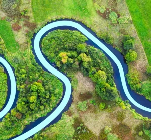
Mitigate Flood Risk and meet sustainability goals with smarter Environmental Data
Insights from the ground up.
Trusted by Local Authorities, County Councils, and Lead Local Flood Authorities (LLFAs) across the UK. Our data-driven reports and expert consultancy provide the certainty you need to manage environmental responsibilities, ensure sustainable urban development, and meet regulatory requirements.
At GeoSmart, we work closely with Local Authorities to provide robust, data-driven solutions tailored to your unique challenges. We understand that balancing the demands of urban development with stringent sustainability and climate change targets is increasingly complex. From Section 19 flood investigations and planning reviews to advanced groundwater modelling, we offer the technical expertise required to protect your communities and fulfil your statutory duties.
With over a decade of experience supporting local government, we help you identify climate, ground, and flood risks early so you can build long-term resilience strategies and make informed planning decisions with confidence.
Why do Local Authorities choose GeoSmart?
Reliable
Proven track record with over a decade’s experience providing support services for Local Authorities, County Councils and LLFAs in England and Wales.
Experts
Direct access to technical experts who offer no-obligation free discussions, tailored CPD training for your staff, and hands-on guidance for policy development.
Definitive
Rigorous modelling approach provides the best quantification of groundwater and climate change flood risk available in the market.
Compliance
Comprehensive planning support covering everything from the review of minor and major planning applications (SuDS, drainage, contaminated land) to S106/S185 agreements.
Reports & Services Local Authorities Typically Need
Section 19 (S19) Flood Investigations
Critical for fulfilling statutory duties under the Flood and Water Management Act, thoroughly examine the causes and impacts of significant flood events and identify clear measures to mitigate future risks.
High-resolution flood maps that identify areas at risk of groundwater emergence, informing your local flood risk management strategies and planning policies on this often-overlooked peril.
Evaluate sustainable drainage options to reduce flood risk, enhance local water management, and ensure proposed developments comply with the National Planning Policy Framework (NPPF).
Projections of future flood risk scenarios to help authorities plan long-term resilience strategies in line with regulatory requirements, powered by our unique FloodSmart Analytics.
We provide comprehensive flood risk assessments, high-resolution flood mapping, S19 investigations, flood resilience surveys, and Sustainable Drainage Systems (SuDS) reports to help local authorities make informed decisions and manage flood risks in their communities.
A Section 19 Flood Investigation is a critical process carried out by Lead Local Flood Authorities (LLFAs) under the Flood and Water Management Act 2010. When a significant flood event occurs, this investigation ensures that the causes and impacts are thoroughly examined, and appropriate measures are identified to mitigate future risks.
Yes. We assist Local Authorities in ensuring that developments meet the requirements of the National Planning Policy Framework (NPPF), including guidance on sustainable drainage, flood risk management, and the risk of contaminated land.
Ready to get in touch?
Trusted by Local Authorities across the UK. Our quick-turnaround reports are clear and compliant, ensuring certainty you need to manage responsibilities, development, and meet regulatory requirements.
“The service provided was efficient and friendly. From the first phone call to GeoSmart they provided a clear, professional approach to my request within the timescales advised. Great service and I would have no problem recommending”
John Childs & Associates
Private Developer
“We are very pleased with the service provided by GeoSmart. Their reports have been used to assist with numerous planning applications and have always been delivered to budget and on-time, much to our clients’ appreciation. We look forward to working with GeoSmart on future projects.”
Planning + Development Associates
Planning & Development Associates
“Efficient and friendly service, GeoSmart provided a clear and concise report within the timescales advised. Great service and I would have no problem recommending”
Vitec Consult
Vitec Consult
“The service for a Phase 1 Contaminated Land Study was excellent, fast and efficient! GeoSmart were willing to assist despite the extremely tight timescale to work with. We will definitely consider using your services again”
Hunter Page Planning
Hunter Page
“The service was great, fast and efficient. Everyone we talked to was very helpful and the details were well received by the planners”
Solid Digital Marketing Ltd.
Solid Digital Marketing Ltd
“Great service! Extremely fast and the report was very detailed and well received by the planners. Many thanks GeoSmart, we will definitely use your services again”
Michael Eyres Partnership
Michael Eyres Partnership LLP
“Everyone involved from initial approach to receipt of report was knowledgeable, efficient and focused”
OeMO Ltd
OeMO Ltd
“I would like to say that dealing with GeoSmart was a seamless experience from beginning to end – thank you for that”
Martin Lloyd Associates
Martin Lloyd Associates
“We were impressed by the speedy, well-informed service and personal contact that we received. The report was thorough and comprehensive. We will certainly use GeoSmart’s services in the future”
Gregory Gray Associates
Gregory Gray Associates
I was concerned to find out that my house was at a ‘moderate risk’ of groundwater flooding. I was unable to get any further information from anyone until I contacted GeoSmart. The staff I spoke to were friendly, helpful, efficient and extremely knowledgeable. The information provided was very site…
Individual Developer
I now purchase GeoSmart’s Groundwater Flood Risk maps regularly – always a very speedy response to the both the initial request and, more importantly, delivery of the data! Excellent customer service too. The data is clear and extremely useful for flood risk assessments.