01743 298100
enquiries@geosmartinfo.co.uk
GeoSmart Information
  • Home
  • Reports
    • Contaminated Land Reports
    • Flood Risk Assessments
    • Sustainable Drainage Reports
    • Detailed Drainage Design
  • Data & Services
    • Groundwater Flood Risk Map
    • SuDS Infiltration Map
    • BGS Geology Datasets
    • User Guides
    • GWFlood
    • GWSewerFlood
    • Flood Risk Portfolio
  • Risk
    • FloodSmart Analytics
    • Case Studies
    • News
  • Knowledge Hub
    • Contaminated Land
    • Flood Risk Assessment
    • Sustainable Drainage Systems
    • Groundwater Flood Risk
    • CPD
    • Videos
    • News
    • Events
    • Blog
    • Library
    • Case Studies
    • Latest GeoSmart e-Newsletters
  • About
    • Our Customers
    • Our Team
    • Our Partnerships
    • Testimonials
    • Careers
    • Our Responsibility
    • A Sustainable Future
    • FAQs
  • Contact

Phase 1 Desk Study and Site Walkover Survey for a New Farm

Posted in EnviroSmart

We were commissioned to undertake an EnviroSmart Plus report to support a future planning application for a new cattle farm and farmhouse. The Phase 1 Contaminated Land Assessment presented a clear and concise overview of the land quality issues presented by former quarrying identified on Site.

The objective of the work was to inform the client of any potential land quality issues on Site to aid a future planning application. The client sought to understand the potential risks to ensure that the application was processed as quickly as possible and to maximise the likelihood of obtaining full approval.

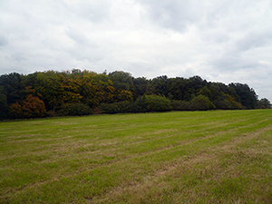
The Site, located near Godalming, Surrey, comprised open fields bounded by woodland to the north and east and a public road to the west. The proposed development was to construct a series of agricultural buildings (namely cattle sheds) and a new farmhouse.

When undertaking an initial review of the Site, it was noted that quarrying may have occurred on Site and in the surrounding area. As such, the proposal included provision for a comprehensive collection of Ordnance Survey National Grid, County Series and Historical Town Plan mapping at 1:10 000, 1:10 560, 1:2 500, 1:1 250, 1:1 056 and 1:528 scales so that the Site’s boundary could be accurately identified in relation to neighbouring land uses over time. On receipt of the mapping information, numerous phases of quarrying were indeed identified on Site, specifically in the area of the proposed farmhouse.

Given the history of quarrying on Site, consultation with the Contaminated Land Officer at Waverley Borough Council was undertaken to establish their particular concerns and access information held by the Council. The Council confirmed that their concerns related to the potential infilling of voids that would have remained on Site following the extraction of quarried materials.

Further to the above, a walkover of the proposed development Site and surrounding area was also undertaken by a qualified GeoSmart consultant. The aim of the walkover was to verify the findings of the data collation activities and also to inspect the site for signs of historical quarrying and subsequent infilling of voids. The Site walkover showed no visible signs of former activity, voids or surface scars, as such it was concluded that infill material of an unknown origin was likely present on Site.

The sensitivity of the site was defined by undertaking a data collation activity in order to draw together an overall picture of the surrounding environment. The principal aquifer (Bargate Sandstone Member – sandstone) beneath the Site is considered to be a sensitive groundwater receptor and the future residential occupation of the Site was considered highly sensitive. The risk presented to surface water receptors and environmental designations was considered low to negligible given the absence of any identified receptors within close proximity of the Site.

An overall risk assessment was produced qualifying the contamination risks posed and the sensitivity of the receptors of concern. The conclusion was that the site was moderate contamination risk given the quarrying legacy and the proposed future use of the Site.

A Phase 2 Geo-environmental Assessment was recommended to be undertaken to fully characterise the ground, ground gas and groundwater conditions across the site.

The client was satisfied that the findings of our report provided a factual account of the possible land quality risks that would satisfy the requirements of the local authority and enable the conditioning of further investigations as part of the application approval.

The EnviroSmart Plus Report delivers both clarity and exceptional value for agricultural Sites where an understanding of potential risks is vital to the future of the business.  They are available for £945 plus VAT including a full set of comprehensive historical maps.

Share this Case Study
« Previous Post
Next Post »

Related Case Studies

Phase 1 Study for a Change of Use from Retail…
Demolition and Replacement Scheme After Flood…
Phase 1 Desk Study for a Change of Use from…
Phase 1 Desk Study for Car Showroom
Mixed Use Land Assessment, Manchester

See what our customers have to say...

"During the conveyancing process for my current house purchase, I was extremely concerned to find the general search results revealed the house was at 'moderate risk of groundwater flooding'. I was unable to get any further information from anyone until I contacted GeoSmart. The staff I spoke to were friendly, helpful, efficient and extremely knowledgeable. The information provided was very site specific and focused. The staff member who talked me through the information and maps provided was very knowledgeable, answered all my questions and allowed me plenty of time to discuss issues. Thanks to GeoSmart for their great service."
Linda Barton
"We were impressed by the speedy, well-informed service and personal contact that we received. The report was thorough and comprehensive. We will certainly use GeoSmart's services in the future"
Gregory Gray
Gregory Gray Associates
"I would like to say that dealing with GeoSmart was a seamless experience from beginning to end - thank you for that"
Martin Lloyd
Martin Lloyd Associates
"Everyone involved from initial approach to receipt of report was knowledgeable, efficient and focused"
Robert McCall
OeMO Ltd
"Great service! Extremely fast and the report was very detailed and well received by the planners. Many thanks GeoSmart, we will definitely use your services again"
Nigel Slack
Michael Eyres Partnership LLP
"The service was great, fast and efficient. Everyone we talked to was very helpful and the details were well received by the planners"
Ben Thorns
Solid Digital Marketing Ltd
"The service for a Phase 1 Contaminated Land Study was excellent, fast and efficient! GeoSmart were willing to assist despite the extremely tight timescale to work with. We will definitely consider using your services again"
Craig Roberts
Hunter Page
"Efficient and friendly service, GeoSmart provided a clear and concise report within the timescales advised. Great service and I would have no problem recommending"
Geraint Harris
Vitec Consult
"We are very pleased with the service provided by GeoSmart. Their reports have been used to assist with numerous planning applications and have always been delivered to budget and on-time, much to our clients’ appreciation. We look forward to working with GeoSmart on future projects"
Alan Gunne-Jones
Planning & Development Associates
"The service provided was efficient and friendly. From the first phone call to GeoSmart they provided a clear, professional approach to my request within the timescales advised. Great service and I would have no problem recommending"
John Childs
Private Developer
Find out more about how we can support you today!
Get in touch
Subscribe to our newsletter
© 2022 GeoSmart Information Ltd.

Suite 9-11, 1st Floor,
Old Bank Buildings,
Bellstone, Shrewsbury,
SY1 1HU

Company No. 5475394

Contact Us
Call 01743 298100
Email enquiries@geosmartinfo.co.uk
Legal Links
  • Privacy Policy
  • CDM Regulations
  • Terms & Conditions
Website by Ascendancy