01743 298100
info@geosmartinfo.co.uk
GeoSmart Information
  • Home
  • Reports
    • Contaminated Land Reports
    • Flood Risk Assessments
    • Sustainable Drainage Reports
    • NEW Detailed Drainage Design
  • Data
    • Groundwater Flood Risk Map
    • SuDS Infiltration Map
    • BGS Geology Datasets
    • User Guides
  • Services
    • GWFlood
    • GWSewerFlood
    • Flood Risk Portfolio
  • Knowledge Hub
    • Contaminated Land
    • Flood Risk Assessment
    • Sustainable Drainage Systems
    • Groundwater Flood Risk
    • CPD
    • Videos
    • News
    • Events
    • Blog
    • Library
    • Case Studies
    • Latest GeoSmart e-Newsletters
  • About
    • Our Customers
    • Our Team
    • Our Partnerships
    • Testimonials
    • Careers
    • Our Responsibility
    • A Sustainable Future
    • FAQs
  • Contact

Government praises “truly innovative” Natural Flood Protection Scheme

Posted on April 14th 2016 in Blog, Flooding

A report from the Environment Agency has conclusively demonstrated the real community benefits of letting nature do much of the work with flood defence protection.

The natural flood management scheme near to Pickering, North Yorkshire proved its mettle during the intense Christmas storms that affected many other towns and villages across the county.

The pioneering scheme which used a series of bunds slowed river peak flow by 15-20%, saving Pickering’s museum and several homes, Environment Agency (EA) analysis revealed.

Pickering has a long history of flooding and whilst a flood alleviation scheme has been proposed in recent years, it is of too low a priority in terms of cost-benefit to be considered for approval. The town is particularly at risk from summer flash floods due to the steep nature of the catchment. It has suffered from four serious floods in the past 10 years.

Slowing the Flow at Pickering is a partnership project. It is led by Forest Research, closely supported by Forestry Commission England, The Environment Agency, The North York Moors National Park Authority, Durham University, Natural England and the wider community. The lead funder is Defra.

The new approach to flood management relies on making changes to the way the landscape is managed, so that the passage of rainfall to rivers and its movement downstream is reduced and delayed. This involves a range of ‘measures’, including:

  • Constructing low-level bunds;
  • Planting more trees, especially along stream sides and in the floodplain;
  • Restoring woody debris dams in small streams;
  • Restoring wetlands.
Natural Flood Protection Scheme - Forestry Commission

Source: Forestry Commission

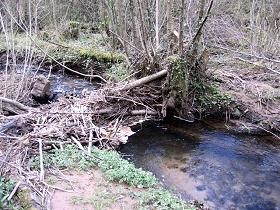
The above to the left shows some placed natural debris in the pathway of the catchment. Large woody debris dams help to increase flood storage by creating an upstream pool and reconnecting streams with their floodplain. Long, low, leaky dams were installed to slow the flow of water off the slopes.

Along with 40,000 extra trees and heather moorland planted upstream, the scheme managed to absorb more than 2ins (5cm) of rain, which fell in the area over 36 hours from 26 December.

The natural scheme was favoured as the alternative was excessively high flood defence walls which would be unsightly and disruptive to the community.

While the EA warned the scheme the scheme would not work in extreme rainfall, it has been praised by Environment Secretary Elizabeth Truss as “truly innovative”.

In a statement, Truss went on to say that natural flood defence measures “can also deliver more benefits than just reducing flood risk such as improving water quality, preventing erosion and in some cases storing carbon.”

“Natural and man-made defences both have a role to play in reducing flooding, but every approach must be tailored to local geography and knowledge,” she said.

Ms Truss is setting out a 25-year plan for the environment, looking at the management of river catchment areas as a whole, to improve flood resilience.

A recent report suggested re-foresting up to 40% of river catchments could help prevent floods.

Stepping up to the natural flood management challenge

Pickering demonstrates how with better data and understanding of river flow, groundwater modelling and runoff within sensitive catchments, the right natural schemes can be implemented with massive community benefits.

GeoSmart is working closely with the Regulator, councils and water companies to model solutions that can be implemented nationwide.

Our recent success at the Geovation Water Challenge for sustainable river catchments will act as a template for how meaningful information can be developed commercially for stakeholders based on local conditions – thereby satisfying the Environment Secretary and Regulator’s key objective.

For more information on our approach, get in touch today.

Posted by DavidKempster
Share this Post
« Previous Post
Next Post »

Latest Articles

  • Increased Groundwater Flood Risk in England
  • CPD webinar: Environmental Information for Masterplanning – 7th April 2021
  • CPD webinar: Understanding SuDS – 24th March 2021
  • CPD webinar: Flood Risk Assessments: A Guide for Architects and Planners – 3rd March 2021
  • CPD webinar: Environmental Information for Masterplanning – 3rd February 2021

EnviroSmart Reports

View Contaminated Land Reports

FloodSmart Reports

View Flood Risk Assessments

SuDSmart Reports

View Sustainable Drainage Reports

See what our customers have to say...

"During the conveyancing process for my current house purchase, I was extremely concerned to find the general search results revealed the house was at 'moderate risk of groundwater flooding'. I was unable to get any further information from anyone until I contacted GeoSmart. The staff I spoke to were friendly, helpful, efficient and extremely knowledgeable. The information provided was very site specific and focused. The staff member who talked me through the information and maps provided was very knowledgeable, answered all my questions and allowed me plenty of time to discuss issues. Thanks to GeoSmart for their great service."
Linda Barton
"We were impressed by the speedy, well-informed service and personal contact that we received. The report was thorough and comprehensive. We will certainly use GeoSmart's services in the future"
Gregory Gray
Gregory Gray Associates
"I would like to say that dealing with GeoSmart was a seamless experience from beginning to end - thank you for that"
Martin Lloyd
Martin Lloyd Associates
"Everyone involved from initial approach to receipt of report was knowledgeable, efficient and focused"
Robert McCall
OeMO Ltd
"Great service! Extremely fast and the report was very detailed and well received by the planners. Many thanks GeoSmart, we will definitely use your services again"
Nigel Slack
Michael Eyres Partnership LLP
"The service was great, fast and efficient. Everyone we talked to was very helpful and the details were well received by the planners"
Ben Thorns
Solid Digital Marketing Ltd
"The service for a Phase 1 Contaminated Land Study was excellent, fast and efficient! GeoSmart were willing to assist despite the extremely tight timescale to work with. We will definitely consider using your services again"
Craig Roberts
Hunter Page
"Efficient and friendly service, GeoSmart provided a clear and concise report within the timescales advised. Great service and I would have no problem recommending"
Geraint Harris
Vitec Consult
"We are very pleased with the service provided by GeoSmart. Their reports have been used to assist with numerous planning applications and have always been delivered to budget and on-time, much to our clients’ appreciation. We look forward to working with GeoSmart on future projects"
Alan Gunne-Jones
Planning & Development Associates
"The service provided was efficient and friendly. From the first phone call to GeoSmart they provided a clear, professional approach to my request within the timescales advised. Great service and I would have no problem recommending"
John Childs
Private Developer
Find out more about how we can support you today!
Get in touch
Subscribe to our newsletter
© 2021 GeoSmart Information Ltd.

Suite 9-11, 1st Floor,
Old Bank Buildings,
Bellstone, Shrewsbury,
SY1 1HU

Company No. 5475394

Contact Us
Call 01743 298100
Email info@geosmartinfo.co.uk
Legal Links
  • Privacy Policy
  • CDM Regulations
  • Terms & Conditions
Website by Ascendancy Internet Marketing