The Role of Telemetry: Actionable Real-Time Flood Data
One of DEFRA’s fundamental responsibilities is to collect and manage data and ensure it is converted into actionable information for citizens, businesses and other agencies.
GeoSmart is a key contributor to this data feed and uses it to ensure communities and clients are prepared and can mitigate flood risks through flood risk planning. A lot of this is now achieved through the power of telemetry. This blog explains how it works and our role in supporting the nation’s flood resilience.
The Environment Agency (EA) operates a network of some 5,500 telemetry outstations, which can be simple river level gauges to complex control structures and pumping stations. The EA has integrated this into their flood information service, which drives the river and sea levels in England service and helps users make informed decisions about potential flooding. Met Office rainfall predictions are added to this to forecast river levels with more certainty of the groundwater flood risk map UK.
Telemetry – already popular and expanding
DEFRA research over the last 3 years has clearly shown the public likes telemetry data – many users routinely check their nearest river level gauging station page during poor weather. More sophisticated users, with good knowledge of local topography and river behaviour, check levels at upstream stations in order to work out what’s coming towards them.
Most monitoring stations communicate using either a physical phone line (known as circuit switch PSTN) or 2G cellular communications. During normal conditions, measurements and other data are collected automatically (or ‘polled’) once or twice a day and the data transmitted back as telemetry.
They’re polled more frequently, typically every 15 minutes, when a high level threshold has been crossed in that catchment and a flood event becomes more likely. Once the flood threat passes, a normal polling frequency is maintained.
Water level data becomes much more useful when network updates are delivered to the online service more frequently, ideally in real time, and aggregated with other datasets.
DEFRA will commence planning for a data communications infrastructure upgrade during the first half of this year. A new platform will allow cellular network IP communications between our telemetry systems and the outstation network, meaning every site can be polled every 15 minutes.
Telemetry in Action: GeoSmart Flood Forecasting Tools
GeoSmart harvests and analyses real-time data to report to our clients when groundwater thresholds are likely to be reached into the future and groundwater flooding could occur. The telemetry we use is from an EA Real Time data API.
Additionally, our groundwater flood forecasting tools feed into the Flood Guidance Statement (FGS) issued by the Flood Forecasting Centre. The FGS provides information for Category 1 and 2 responders to help them with their emergency planning and resourcing decisions. It presents an overview of the flood risk for England and Wales across five days and identifies possible severe weather, which could cause flooding and significant disruption to normal life.
The FGS provides a comprehensive and consistent national approach to river, groundwater, tidal/coastal and surface water flooding in one place.
We feed groundwater data into our models alongside rainfall prediction data from climate models to obtain forecast groundwater levels at more than 30 locations. We can get insights into the spatial variation in groundwater levels and flooding likelihood up to 30 days ahead.
Right now, groundwater levels are generally low, following a dry January – in fact, the UK had 52% of average rainfall making it the driest January since 2006. Overall, England received average quantities of rainfall in November and December 2018, while the south west received higher than average rainfall.
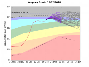
Before Christmas, groundwater was high in the Cotswolds but flooding did not take place. Our groundwater flood forecasting service predicted what would happen over the holiday period.


The charts show hydrographs before and after Christmas at Ampney Crucis in Gloucestershire.
The sharp upward curve before Christmas gave cause for concern and modelled trends at the upper end of the scale to run close to the threshold level for groundwater flood emergence into early Jan, as shown in the range of levels based on ensemble rainfall predictions (purple lines) and historical rainfall (grey lines).
With a drying sequence noted, we were able to predict that the forward trend meant that the threshold would not be breached and could provide reassurance to users that they did not need to increase standby provision
The picture is now changing significantly as more Atlantic weather systems are brought in on a more active jet stream.
Our users continue to monitor our live, interactive website to view groundwater levels across England, obtain insights on flooding, and review how changes will affect sewers and critical infrastructure.
For more information about our Groundwater Flood Forecasting Service and the work we do in support of the Flood Guidance Statement, contact us on 01743 278100 or email info@geosmartinfo.co.uk


