Forecasting groundwater flooding in 2019 and 2020
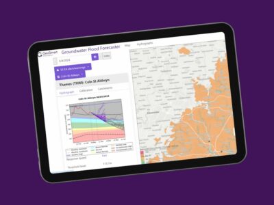
GeoSmart Information is forecasting groundwater flooding by providing the Flood Forecasting Centre (FFC) with a groundwater flood forecasting service for a fifth year. FFC will use the groundwater flood forecast service to support operational decision making on groundwater flood risk for the Flood Guidance Statement and FFC Monthly Outlook products (providing a 30-day high-level look ahead). The service provides the FFC with up-to-date situational awareness of national groundwater conditions as well as a national forecast of potential flooding to inform them when to approach Environment Agency local teams to discuss and agree the groundwater flood risk for the next 5 days.
The cutting-edge tool utilises live telemetry feeds of groundwater data, predicted ensemble rainfall data and a sophisticated modelling approach. Forecast hydrographs for indicator boreholes give the current situation and forecast trends for groundwater levels for a range of scenarios. Hydrogeology experts at GeoSmart are ready to support interpretation of the groundwater flood forecast on a daily basis as required.
A geospatial view of the groundwater situation is available via a web map supporting an easy assessment of risk and forecast data is also available for direct import into other applications. High risk locations are highlighted on a map of the UK through an interactive interface, indicating those areas where groundwater flooding is possible.
GeoSmart continues to enhance the service with additional boreholes increasing coverage and providing finer resolution for forecasting of groundwater flooding. Users will get improved insights this season with easily accessible information on performance of the model and aquifer response time.
The groundwater service is used by Local Authorities in combination with GeoSmart’s groundwater flooding map (GW5) which indicates risk of flooding at high resolution.
GeoSmart also provides a sewer infiltration forecast to water companies. The service helps companies to plan and take action to safeguard property and ensure continuity of essential services. The service can integrate with live hydrologic integrated catchment models (such as Innovyze’s ICMLive) providing alerts to start pumps and initiate manhole checks, and to give groundwater level inputs, reinterpreted as infiltration rates, to sewer and drainage networks. Digital Twin and BIM concepts are increasingly used by water companies to optimise performance of existing assets and increase the efficiency with which they are operated and maintained. An increased understanding of groundwater can enhance the accuracy of Digital Twin models.
Currently there is a diverse groundwater situation across England. Groundwater levels are already exceptionally high in the Lincolnshire Limestone aquifer (Leasingham and Grange de Lings) and in Cotswold Limestones aquifer (Ampney Crucis) following above average rainfall in September and October. Groundwater levels in Wessex in chalk geology are also high. Further east, recharge has only just begun with groundwater levels below normal.
Contact us today if you wish to discuss any of our groundwater flooding services.


