Planning practice guidance: what has changed in the flood risk and coastal change update?
Contents
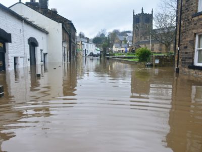
The government has renewed its flood risk and coastal change planning guidance in an effort to make new developments more resilient to severe flooding.
According to Levelling Up Secretary Greg Clark, the updated guidance will enable councils to impose stricter rules for future developments, with the aim of making buildings that are designed to last.
Flood risk assessments and design considerations have both undergone significant changes and councils are now required to show that a development can withstand flood risks over its lifetime without increasing flood risks in the surrounding area.
In accordance with the new guidance, GeoSmart Information has incorporated the new changes into its flood risk assessments and drainage strategies.
Here’s what has changed in this latest iteration…
Strategic and site-specific flood risk assessments
Since the previous edition of the planning practice guidance, there have been some notable changes to the process of assessing and avoiding flood risk.
Strategic policy-making authorities, previously known as local planning authorities, should undertake strategic or site-specific flood risk assessments where appropriate and such assessments need to be carried out to obtain a grant of technical details consent.
The specified content of flood risk assessments has been amended too; strategic or site-specific flood risk assessments should show consideration of all flood sources and account for climate change factors within this.
The new guidance has also declared that assessments need to outline the extent of the functional floodplain, show regard for emergency planning and protect future flood storage areas.
Other new requirements for flood risk assessments include:
-
Identifying sources of uncertainty on a site and outlining how these can be resolved in a mitigation strategy
-
Establishing ‘the most vulnerable aspects of development’ in site’s situated in areas with a low flood risk, unless there are ‘overriding reasons to prefer a different location’
-
Demonstrating regard for both vertical and residual flood risks and suggesting ways to avoid both
-
Regarding the impact of flood risk management infrastructure failing or its design standard being exceeded
-
Identifying how flood risk management infrastructure will be ‘operated, funded and maintained’
-
Ensuring there is capacity for future maintenance or new flood risk management infrastructure that might be required
-
Taking climate change factors into account and considering if there will be available funding for flood defences in future
-
Assessing how a development could affect flood risk in the surrounding area
The sequential and exception tests
Unlike the previous iteration, the new guidance has stated that the sequential test, an analysis that compares sites to determine which has the lowest flood risk, needs to be agreed with the Local Planning Authority at an early point in the planning process.
If this test isn’t carried out to a satisfactory standard, sites that are situated in medium to high flood risk areas will not be approved.
Guidance for the exception test has been clarified too – a development’s suitability benefits for the community can outweigh flood risk.
If plans fail the sequential test, the guidance has also stipulated that they cannot be validated by the exception test.
Equally, if the plans pass the sequential test but fail the exception test then they cannot be approved and planning permission should be refused.
Planning for flood risks
Following its amendment of flood risk assessment specifications, the revised guidance also revealed a new decision-making hierarchy to support flood risk planning.
Beginning with the application of the sequential approach, and exception test if required, the structure has been divided into three paragraphs – ‘Control’, ‘Mitigate’ and ‘Manage’.
The first has promoted the establishment of strategic management methods to control flood risks, such as securing funding from the developer to ensure the development is delivered and maintained effectively.
The second stage of the hierarchy has advised that development features which could facilitate flooding, should be designed out and replaced with measures to facilitate flood resistance and resilience.
Following this, the third paragraph has suggested that residual flood risks should be controlled after avoidance, control and mitigation approaches have been undertaken.
Consideration of this should be made apparent in plans alongside comprehensive flood warning and emergency planning.
Design considerations
Another area which has been rejuvenated is the guidance for the design process – the focus has been placed on designing to lessen a development’s negative impact on user safety, flood storage and flood risk in the surrounding area.
The guidance has stated that flood-resistant design should accommodate all members of society and demonstrate that users could safely access and egress the development in a design flood (hypothetical flood).
From a structural perspective, professionals involved in projects which involve historic buildings should consult Historic England as soon as possible to minimise future hazards.
The guidance has been very clear about this matter and has stated that ‘tensions between flood risk mitigation measures and other planning matters, do not justify unsafe development.’
This sentiment underscores the guidance’s new assertion that using voids to compensate for the loss of floodplain storage is no longer acceptable.
In cases where flood storage has been lost due to a development, on-site level-for-level compensatory storage which regards the predicted impacts of climate change over a development’s lifetime should be provided.
The guidance has stated that a residential development’s lifetime is considered to be 100 years and 75 years for a non-residential development.
Preparing plans
Prior to any consultations with authoritative or regulatory bodies, plans for a development are required to be examined by a strategic flood risk assessment.
According to the guidance, sites located in an area with low flood risk will be considered for approval first with medium-risk sites only regarded if the identified low-risk sites are deemed to be insufficient.
Developments in high-risk sites will only be considered for approval if both medium and low-risk sites are not sufficient.
In addition to this, the guidance has reinforced the importance of early consultation with organisations for informed flood risk advice, a list of bodies to which the Environment Agency, lead local flood authorities, water and sewerage companies, emergency planners, emergency services, local resilience forums and other flood incident responders have been added.
SuDS
Guidance on sustainable drainage systems (SuDS) has been elaborated upon with more focus on what is required for the implementation of SuDS.
The promotion of early consultation for SuDS incorporation has been reinforced and multi-functional sustainable drainage systems have been put forward as the preferred approach.
A drainage hierarchy has even been included in the guidance. It appears as follows:
-
into the ground (infiltration);
-
to a surface water body;
-
to a surface water sewer, highway drain, or another drainage system;
- to a combined sewer.
Flood zone update
Flood zone 3b, which previously had a vague description, has been updated to refer to ‘land where water from rivers or the sea has to flow or be stored in times of flood.’
More important though is that flood zone 3b now denotes land that has a 3.3 per cent or greater chance of flooding meaning more land is classed as part of the Functional Floodplain and the potential for development and redevelopment has been limited.
Visit our flood zone page for more information.