How can tracking groundwater levels predict water scarcity?
Contents
- How do droughts impact our water supply?
- Why is groundwater important?
- How can GeoSmart’s GWFlood predict water scarcity?
- Worried about groundwater flooding?
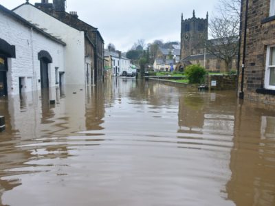
The UK’s green and pleasant land has been left a dry and barren desert following an ongoing period of drought – the likes of which haven’t been seen for 50 years.
Conditions have been so bad that Thames Water announced a hosepipe ban, which was enforced from 24th August 2022, after the River Thames dropped to its lowest level since 2005.
Yet according to some scientists, these circumstances should come as no surprise; climate research projected the magnitude of heatwaves and droughts we have just experienced, several years ago.
If greenhouse gas emissions continue to rise, UK climate predictions have stated that our summers will become drier, droughts and water shortages more frequent.
In this future scenario, we need to be able to predict how much water we have available so that we can manage our use of it more efficiently.
How do droughts impact our water supply?
The Intergovernmental Panel on Climate Change refers to four types of drought. These are:
- Meteorological drought – when rainfall in a specific location is lower than average for that area
- Agricultural drought – when crops and farming practices are impacted by dry soil or a lack of rainfall
- Ecological drought – this is similar to agricultural drought but also refers to when the local environment is impacted by water scarcity too
- Hydrological drought – when low rainfall, lack of snow melt and other factors cause water sources like reservoirs and streams to drop
Unfortunately, we are likely to see an increase in all these types of drought as global temperatures rise.
In the scientific text, Global Climate Change, Abhishek Kumar, Shilpi Nagar and Shalini Anand stress that a hotter climate will cause water molecules to evaporate more quickly and a temperature rise of 3°C could raise the intensity, duration and frequency of droughts in future.
If this were to occur, global water availability would decrease and cause the world’s agricultural systems, civilizations and ecosystems to suffer greatly.
According to Peña-Guerrero et al., 70 percent of fresh water is used for irrigation which, in the context of hotter temperatures, would particularly impact agricultural systems in semi-arid environments where a lack of access to fresh water stress is already an issue.
Droughts will continue to prove devastating for UK rivers too; the reduced quantity and flow of water leads to a higher concentration of sewage effluent and wastewater pollutants like phosphates, nitrates, pharmaceuticals and organic chemicals in our watercourses.
Why is groundwater important?
Groundwater describes the water that is located in rock and soil pore spaces beneath the Earth’s surface.
It can also be found in the fractures of rock formations and is an extremely important resource, making up one third of the world’s fresh water supply and 30 percent of the UK’s public water supply.
Used largely for irrigation and drinking water, groundwater is discharged via rivers, streams, springs, lakes or wells and has an important role in dictating the level of the water table and the recharge and regulation of our river systems.
Our reliance upon groundwater is such that changes in groundwater levels have direct implications for wildlife, industry, agriculture and the public’s water consumption.
GeoSmart’s Director of Product Development, Paul Drury said: “In summer months, and especially during drought conditions, it is normal for the water table to get lower and to reach seasonal lows. The groundwater within the hydrological cycle is then recharged again through accumulated rainfall in the autumn and winter.
“However, if we continue to have a lack of rainfall for the rest of the summer, and experience lower than average rainfall in the later part of the year, the UK will face challenges of water scarcity.”
How can GeoSmart’s GWFlood predict water scarcity?
GeoSmart’s Groundwater and Sewer Infiltration Forecasting models provide monitoring of groundwater levels and predictive modelling of future conditions.
The software solution achieves this by considering current groundwater levels and weather forecasts to determine the likely rise and fall of groundwater levels for several weeks into the future.
During periods of drought, this information is useful as it can provide data to predict water scarcity – if local authorities and water utility companies know how much available water there is, they can use this information to optimise their management of water resources.
“GeoSmart’s Groundwater forecasting solution is providing water companies with dynamic predictive analytics of groundwater levels which are based on borehole gauge telemetry and weather forecasts,” said Paul.
“This enables prior warning of likely flood conditions and water scarcity which informs smarter response decisions.”
Throughout August 2022, GeoSmart has been monitoring boreholes across the South East of England, an area which has been hit hard by drought conditions.

The image above shows a borehole telemetry reading up to August 2022 which displays a drop in monitored and predicted groundwater levels below the average monthly minimum.
GeoSmart’s results have shown that groundwater levels in this region are well below what is considered to be normal in any given year.
These drought conditions have been predicted to continue throughout the summer, although recent bouts of rainfall have been predicted to have alleviated the problem to a small degree.
Worried about groundwater flooding?
To manage groundwater risk effectively, local authorities and water utility companies in the UK are turning to GeoSmart for solutions.
The Groundwater Flood Risk Map shows areas where groundwater flooding can occur and details the severity of risk.
If you are concerned that your asset or those of a client’s are at risk from groundwater flooding, get in touch with our team today.